
The interactive map below will guide you along the Isle of Wight's Sophie Dawes Trail. Just click on any of the numbers to discover the locations and features along the way and for directions on how to proceed from one to the other. And if you would like a more detailed discription at any stage, a small booklet is available with lots more information on the history and heritage of the area itself. Details here.


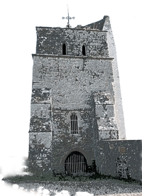
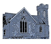
Start your walk from the car park overlooking the sea. The ruins of the old church, can be seen to your right. After many years of neglect and decline, the tower was made into a 'seamark' (to guide ships at sea). A brick wall, whitewashed for visibility, supports the old tower on the seaward side, and these days the area is flanked by a grass common and a pleasant picnic area.
From the old church tower, walk southwards along the esplanade in front of the car park and with a cafe and beach huts made from old railway carriages on your right. Continue to the very end of the esplanade and then onto the turf and sand. You are now looking out over the waters between the Duver and Bembridge harbour.
The waters and the inlet between St Helens and Bembridge, leading into the Haven, have several features named in memory of a well-known local fisherman Dickie Dawes (b.1751) who is also reputed to have supplemented his income through smuggling. Today, Bembridge is home to numerous sailing boats and a lifeboat station.
From your position at the tip of the Duver, retrace your steps if necessary to locate the track to the north of the cluster of buildings nearby. This leads westwards and then north-west along a rough roadway until a footpath (unsigned) to your left takes you across the Western portion of the Duver.
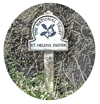
Home to wildfowl, wading birds, ramblers and boatyards, the rugged sand and grass spit known as the Duver was also once a 9-hole golf course frequented by the Prince of Wales in Victorian times, but which closed in 1961. The land was subsequently taken into ownership by the National Trust. There are outcrops of windswept trees and bushes and some unusual local plants to look out for.
The wall to an ancient tidal pond to the north of the Haven makes for a unique and spectacular walkway - albeit a rather narrow one in places. Running in an almost straight line towards the south-west, it is a great favourite with local dog walkers, as well as an ideal platform for bird watchers and the occasional angler.
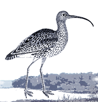
A leisurely walk along the mill wall is recommended, not least because there is so much to observe either side. The Haven to your left and the mill pond to your right are home to many varieties of seabirds and waders. And plenty of boats on show. At the end you emerge around a sharp corner and alight upon an attractive open area bordering the quayside.
Although the original mill house has been replaced by a modern home, it is still possible to see the sluice gates along the causeway and the inlet for the water wheel that drove the mill. The water, collected into the pond, would have exited into the quay. It would have been a busy place in olden times - and still an active area today with a boatyard and yachts.
From the Quay, continue along the road northwards and uphill, with views back over the Duver to your right hand side, until you reach the open expanse of the village green. Turn left here and walk south-west. The trail continues with a right turn across the road, up towards a sports pavilion and car park on your right.
The visitor to St Helen's green will not find a more varied and delightful variety of buildings anywhere. Every house and cottage is different to its neighbour. Geese used to graze here. There are shops and places to eat, and a fabulous second-hand book shop by the name of 'Mother Goose.'
From the north of the green, locate the narrow lane to the side of the Vine Inn. This takes you northwards across a cul-de-sac and then to the start of 'Broomlands' - a long footpath leading up to a busy main road. Cross the road a little to your right to locate a footpath leading diagonally north-west across a large field. Go through the gate at the end, and the entrance to the church is just a few yards westward along the road.
The new church was built in 1717 replacing the old one by the seashore. It has a single tower with a bell and is unusual in being quite some distance from the settlement that it serves. Among the graves outside can be found that of James Dawes, the nephew of Sophie who died suddenly in Calais in 1831 while travelling in the company of his aunt.
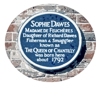
From the church, retrace your steps back across the field, over the road, then back down Broomlands path until you reach the village once more. Turn right at the end of the path, past a school on your left hand side, then around and down to the main village road. Walk eastwards until you find the brick cottage with the blue plaque on the wall: the birthplace of Sophie Dawes.
The building where Sophie was born sits in a charming position overlooking the green. Named 'Freefolk Cottage' it is a private residence, but marked with a distinctive blue plaque, so easy to locate. It must look fine in the springtime when the wisteria above the door is in bloom.
Continue eastwards along the main road ignoring the sharp bend to the left - and carry on straight ahead down a lane (the Duver Road). After a few yards and a narrow bridge with traffic lights, you see an open area and gate to your right - with a magnificent vista looking out over the Haven below. This is the top of the Gaggun Path.
The curious name allegedly comes from being a spot where press gangs once used to hide up to capture men to crew the ships at sea. So it is derivative either of the word 'gang' or perhaps less likely 'gag'. Continue down this ancient footpath and out onto the windswept Common below.

Locate the rough pathway leading south-east, crossing a roadway and then eastwards between a gap in the trees ahead. A narrow sandy few yards of pathway brings you back to the esplanade, from where you can return to the car park overlooking the sea.
There is a handy café nearby, and a WC also - though if you are visiting at an off peak time, be advised that both might be closed especially during the winter months.
Please always be mindful of farmers and those who work in the countryside.
